Descripción
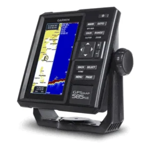
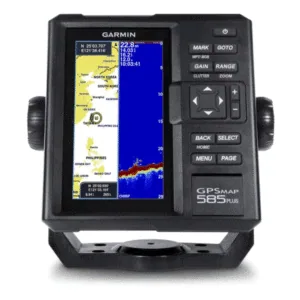
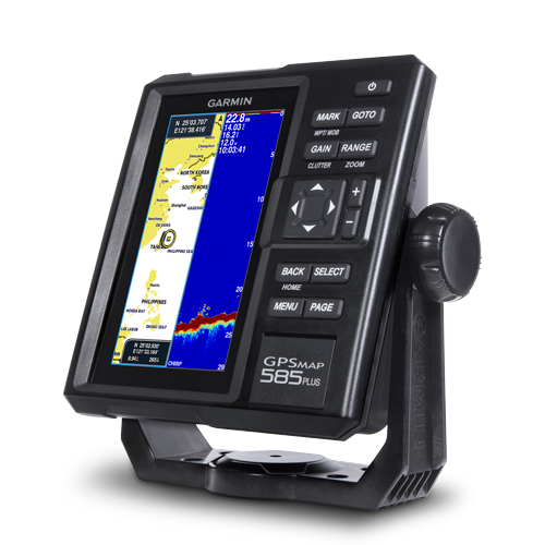
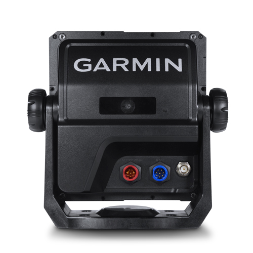
GPSMAP® 585 Plus — 6” con CHIRP, ClearVü y Quickdraw (sin transductor)
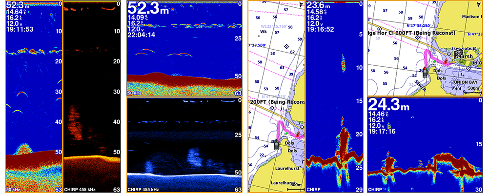
Encuentra spots de pesca y vuelve a ellos con la potencia del sonar CHIRP de Garmin.
El GPSMAP 585 Plus ofrece pantalla 6″ WVGA vertical, interfaz con
botones dedicados, CHIRP 600 W y CHIRP ClearVü para imágenes tipo fotográficas.
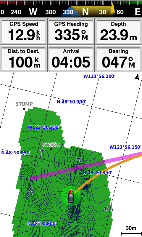
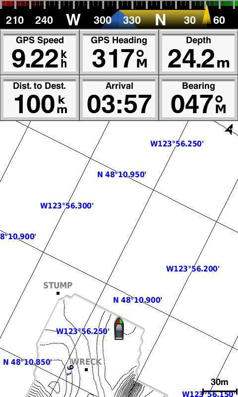
Soporta GPS/GLONASS/BeiDou, guarda hasta 12.000 waypoints y trae
Quickdraw™ Contours para crear tus propios mapas HD al instante.
Por qué elegirlo
- CHIRP + ClearVü: arcos más nítidos y mejor separación de objetivos.
- Quickdraw™: genera mapas HD con curvas de 1 ft mientras navegas/pescas.
- Triple GNSS: GPS/GLONASS/BeiDou para posicionamiento rápido y preciso.
- 12.000 waypoints: marca hotspots, peligros y rutas sin límites.
- Auto Guidance (con cartas compatibles): te sugiere una ruta evitando bajos y obstáculos.
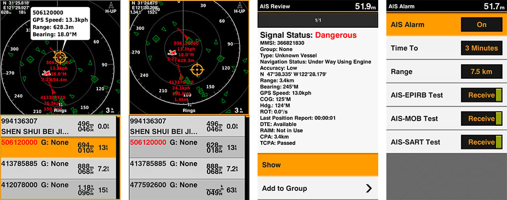
- AIS Radar view: lista y radar AIS en la misma pantalla; VRM/EBL y detalle de embarcaciones.
- Conectividad: NMEA 0183/RS422 para integrar VHF/DSC y sensores 3ros.
- 2 ranuras SD™: expande mapas (BlueChart®, LakeVü™ HD Ultra, g2/g2 Vision®).
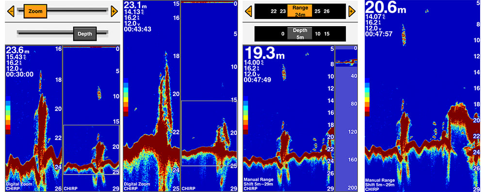
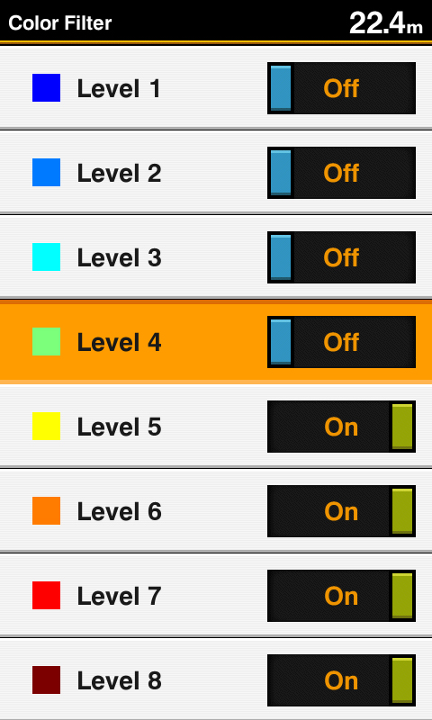
- Herramientas pro: Zoom digital/shift, filtro de color en sonar tradicional, secuencia rápida PAGE.
- Multi-idioma: Español, Inglés, Chino, Japonés, Coreano, Indonesio, Malayo, Vietnamita, Birmano, Tailandés.
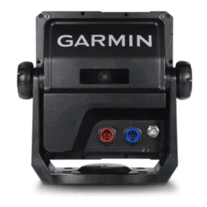
Esta versión se vende sin transductor. Requiere transductor 8-pin compatible (popa o thru-hull) según casco y profundidad.
Características técnicas
| Pantalla | 6″ vertical, WVGA color (480×800), alto brillo |
|---|---|
| Sonar | CHIRP tradicional 600 W (RMS) + CHIRP ClearVü |
| GNSS | GPS / GLONASS / BeiDou |
| Waypoints | Hasta 12.000; rutas y Tracks compatibles |
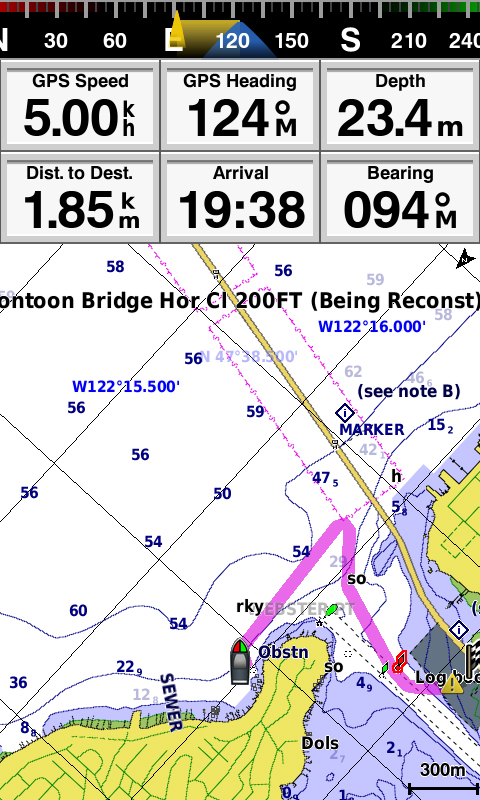
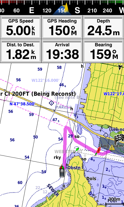
| Mapas | Quickdraw™ Contours incluido; compatible con Garmin BlueChart®, LakeVü™ HD Ultra, g2/g2 Vision® |
| Conectividad | NMEA 0183 / RS422; GPX transfer; 2× ranuras SD™ |
| Funciones | AIS Radar & lista AIS, Auto Guidance, Zoom/Shift, Filtro de color sonar, botón PAGE |
| Resistencia | IPX7 |
| Transductor | No incluido (conector 8-pin) |
Transductores compatibles (ejemplos)
- GT21-TM (8-pin): tradicional 600 W (50/200 kHz) + ClearVü CHIRP 500 W (260/455 kHz) — popa.
- GT20-TM (8-pin): tradicional + ClearVü para aguas someras — popa.
- Airmar y thru-hull 8-pin según tipo de casco (consulta instalación).
La elección del transductor depende de material del casco, montaje y profundidad objetivo.
¿Necesitas transductor? Contáctanos y te asesoramos (GT21-TM, GT20-TM u otras opciones).
Encuentra zonas de pesca con precisión usando el GPS MAP 585 Plus
El GPS MAP 585 Plus es la herramienta definitiva para pescadores que buscan rendimiento y precisión. El puerto para transductores soporta sonares CHIRP tradicionales de 600 W y ClearVü, podrás visualizar imágenes nítidas del fondo marino, estructuras sumergidas y arcos de peces bien definidos. Gracias a su compatibilidad con los sistemas GPS, GLONASS y BeiDou, puedes registrar hasta 12.000 puntos de interés para volver a tus sitios de pesca favoritos con facilidad.
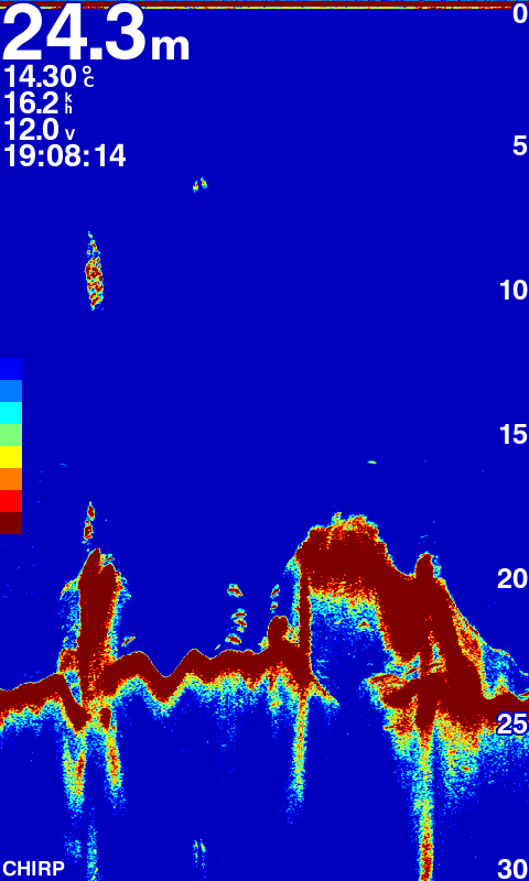
Potente sonar CHIRP y ClearVü: Imágenes como nunca antes
Con la avanzada tecnología de Garmin CHIRP, el GPS MAP 585 Plus realiza un barrido continuo de frecuencias, logrando una separación de objetivos superior y una visualización clara de cada pez. Cuando se utiliza con un transductor ClearVü proporciona imágenes casi fotográficas del entorno submarino, combinando HD-ID y ClearVü. Estas funciones convierten al GPS MAP 585 Plus en una herramienta esencial para pescar de manera más inteligente y precisa.
Pantalla WVGA de 6” y funciones avanzadas de navegación
Diseñado para todo tipo de pesca, cuenta con una pantalla vertical de 6 pulgadas en color, con botones dedicados para un uso intuitivo incluso en condiciones exigentes. Incluye el software Quickdraw Contours que crea mapas HD personalizados al instante. También es compatible con mapas BlueChart® g3 y BlueChart® g3 Vision®, que ofrecen funciones de navegación avanzadas y te permite tener un mayor conocimiento de tu entorno.
Soporte multilenguaje y conectividad total
Este equipo está optimizado para el mercado global, con soporte multilingüe que incluye inglés, chino, japonés, coreano, tailandés y más. Ofrece compatibilidad con sensores NMEA0183 y RS422, además de dos ranuras para tarjetas SD™ que permiten guardar rutas, mapas y waypoints. Incluso puedes transferir datos desde otros GPS mediante formato GPX. Ideal para quienes buscan un ecosonda robusto, con tecnología de vanguardia y facilidad de uso.
Ideal para pesca costera y en aguas profundas
El GPS MAP 585 Plus se adapta perfectamente tanto a la pesca costera como a la de alta mar. Su capacidad para identificar el fondo marino y localizar cardúmenes con precisión permite planificar mejor cada jornada de pesca. Gracias a su gran capacidad de almacenamiento de puntos y compatibilidad con múltiples tipos de mapas náuticos, tendrás siempre una visión clara del terreno bajo tu embarcación. Ya sea en aguas poco profundas o explorando zonas más lejanas, este ecosonda ofrece el rendimiento necesario para maximizar tus capturas.
Incluye
- GPS Map 585 Plus
- Cable de poder / datos
- Accesorio de montaje
- Documentación
Find fishing spot, Catch fish with the Power of Garmin CHIRP
- Multi language support : English, Simplified Chinese, Traditional Chinese, Japanese, Korean, Indonesia Bahasa, Malaysia Bahasa, Vietnamese, Burmese, Thai.
- Available in 6-inch WVGA color, portrait mode display. Offers a keyed interface with dedicated buttons.
- CHIRP sonar sends a continuous sweep of frequencies ranging from low to high. CHIRP sonar is able to create crisper fish arches with better target separation.
- Built-in 600 W (RMS) CHIRP traditional sonar and CHIRP ClearVü scanning sonar gives a clearer picture of what’s below the boat as a photographic image with representation of objects, structure and fish.
- Compatible with GPS, GLONASS and BeiDou powerful positioning systems what quick and easy to drop up to 12,000 accurate waypoints let you find your way back to your secret fishing hot spots.
- Free, easy-to-use Quickdraw Contours software instantly creates personalized HD fishing maps is included.
- GPSMAP 585 Plus supports for typical NMEA0183 and RS422 communication within 3rd party sensors and accessories.
- 2 standard SD™ card slots provides expandable memory for accessory map purchases such as LakeVü HD Ultra maps and BlueChart® g2 Vision® charts.
The all-new GPSMAP 585 Plus chart plotter / sonar combo is available in 6-inch display. GPSMAP 585 Plus is offered a worldwide basemap and support all Garmin marine charts also with Asian multi language support and developed the target for semi-commercial fishing market. GPSMAP 585 Plus gives you high wide CHIRP sonar and CHIRP ClearVü scanning sonar capabilities which shows crisp fish arches with excellent target separation and provides clear images of structure below the boat. Supporting GPS, GPS + GLONASS, GPS + BEIDOU 3 kind of positioning modes. New Garmin Quickdraw™ Contours software included lets you create your own maps, with up to 1-foot contour lines, on any body of water.
The Power of Garmin CHIRP
The built-in sonar capabilities of GPSMAP 585 Plus includes CHIRP sonar, the most sophisticated sonar technology available for the fishing and boating public. CHIRP sonar provides amazingly clear target separation and definition because it puts even more energy onto the target than traditional sonar. It also includes sonar-recording capability that coordinates the timing of the sonar return with your boat’s position and saves digital information for playback on a computer using HomePort™ planning software. Use the user data sharing cable to share waypoints and routes between multiple devices.
Clearest Scanning Sonar on the Water
Garmin CHIRP ClearVü scanning sonar gives you a nearly photographic image down below your boat. Traditional Garmin HD-ID™ sonar and ClearVü scanning sonar are combined into 1 transducer.
With the Best Maps on the Water Supporting
Two standard SD™ card slots provide expandable memory for accessory map purchases such as BlueChart® g2, BlueChart® g2 Vision®. The BlueChart g2 Vision provide exclusive Garmin Auto Guidance, a technology that directs you to your hot spots. Based on your boat’s specifications, Auto Guidance instantly creates a visual path you can follow to avoid shallow water and other charted obstructions.
Quickdraw Contours: Create Your Own HD Maps
Quickdraw Contours is a free, easy-to-use software feature already installed on your GPSMAP 585 Plus. It instantly creates your own personalized HD fishing maps on screen with 1-foot contours. Tailor the maps as needed; you own them. Keep the data for yourself, or share it with Garmin or your friends. No special surveying expertise is required. You just fish while Quickdraw Contours creates maps. There’s no waiting around or sending your files away like other mapping software requires — your results appear instantly.
Compatible with GPS, GLONASS and BeiDou
With multi positioning modes supports to GPS, GLONASS and BeiDou three powerful systems. It is quick and easy to drop up to 12,000 accurate waypoints and find your way back to your secret fishing hot spots. Huge capacity memory to help fishermen record danger spot(Mark) and the destination(Waypoint).
AIS Radar Support
Show you the detailed AIS Radar view and AIS list at the same page. Move the cursor and review particular item on the radar view to see the detail information of highlighted vessel. Drop VRM/EBL and measure distance on the AIS Radar view window and to focus a AIS vessel through the AIS list to see the detail of it.
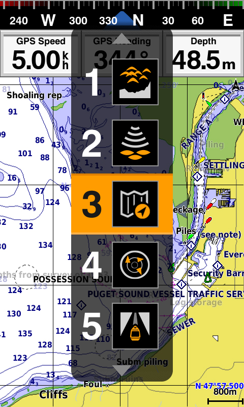
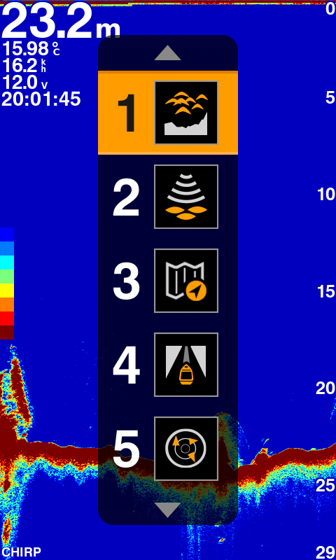
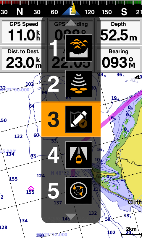
Quick PAGE Sequence
Dedicated PAGE button to have a quick features exchange. Press the “PAGE” button to let user can switch from frequently use feature one by one quickly. With holding the «PAGE» button user can edit their prefer 5 frequently use pages themsleves.
Digital Zoom and Shift Zoom Supporting
Digital Zoom and Shift Zoom features let you control your owned display portion as what you prefer to shows in detailed.
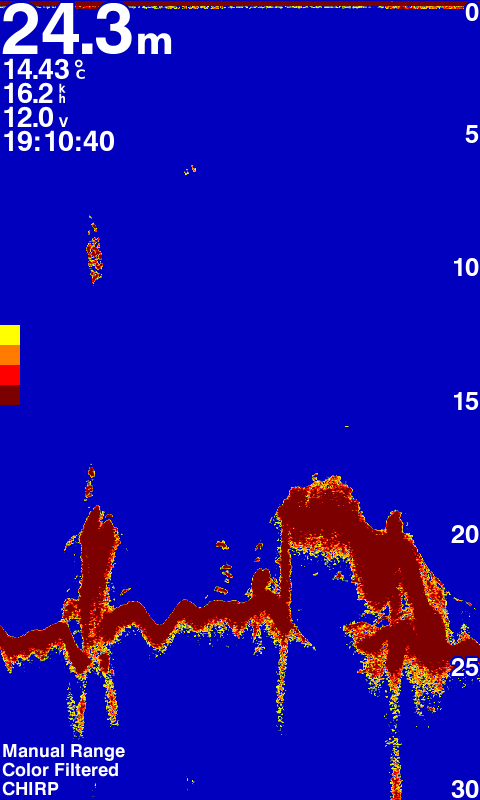
Color Filter for Traditional Sonar Display
8 color levels let users can switch the toggle to turn ON/OFF the specific color on traditional sonar page with their owned preference to show the sonar display.
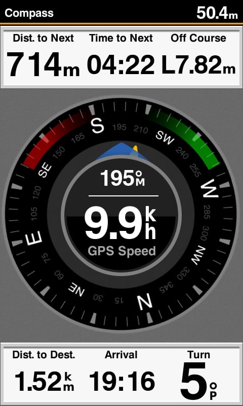
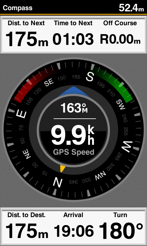
Compass Page to Know COG and SOG at A Glance
Display speed and heading at one page shows to semi-commercial fishermen. They can rely on these information to judge whather the net is full or not while trawling and understand to align the direction of casting the net just at a glanc.
Enhanced Auto Guidance
Just enter the location where you want to go and patented Garmin Auto Guidance technology instantly searches through relevant charts to create a safe, virtual pathway on the display that helps you avoid low bridges, shallow water and other charted obstructions en route.
With enhanced Version 2.0, you have access to more features and capabilities. You’re able to adjust the calculated Auto Guidance pathway by inserting via points at interim stops or landmarks along your desired route. You can easily review hazard points along your calculated path. Other 2.0 enhancements give you the ability to calculate arrival times at any point on your route (great for timing arrivals to correspond with bridge openings and other time-critical events). Better still, you can now save your plotted Auto Guidance paths for future navigation by backing them up on an SD™ card with your BlueChart g2 Vision or LakeVü HD Ultra cartography¹.
GPX Waypoints Transfer
If you have waypoints, tracks or frequently used routes stored on another manufacturer’s GPS product – or on a Garmin handheld device – now it’s easier than ever to transfer those items to your new Garmin chartplotter, via industry-standard GPX software formatting. GPX is an open standard format for GPS data exchange across platforms and applications. With this easy-to-use interface technology, Garmin has taken “no waypoint left behind” to a whole new level of trade-up convenience.

Valoraciones
No hay valoraciones aún.